
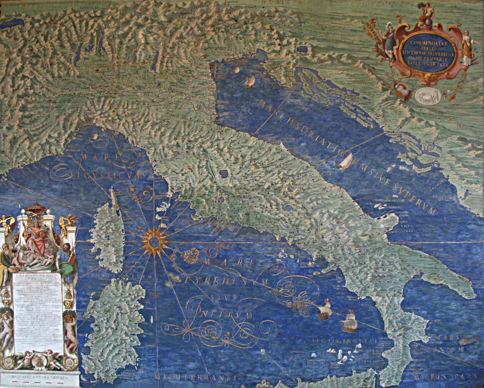
Walk the Vatican Museums’ standard route and you will spend somewhere between six and ten minutes inside the Gallery of Maps. A hundred and twenty metres of corridor, six metres wide, gilded ceiling above, forty large frescoed maps of Italy on the walls. Most visitors register it as one of the more beautiful passages between the Egyptian rooms and the Raphael Rooms, take a few photographs of the ceiling, and keep moving.
What almost nobody explains is what the room is actually doing. Ignazio Danti painted these maps between 1580 and 1583, on commission from Pope Gregory XIII, in under two years. The Gallery is a political document as much as it is a decorative one. Once you know what it is arguing, it is difficult to walk through it the same way again.
Who Danti was, and how he ended up in Rome
Pellegrino Rainaldi Danti was baptised on 29 April 1536 in Perugia. He took the name Ignazio (sometimes Egnatio) on entering the Dominican Order in 1555, and spent his working life as a mathematician, astronomer, and cosmographer. He died Bishop of Alatri in 1586.
Before Rome, Danti worked for Cosimo I de’ Medici in Florence from about 1567. His main project there is the reason he became famous: the map cupboards in the Sala delle Carte Geografiche of the Palazzo Vecchio, a Medici cabinet of the known world drawn on the inside of two dozen wooden doors. When Cosimo died in 1574, Danti fell out of favour with the new grand duke Francesco I and was effectively expelled from Florence. Gregory XIII summoned him to Rome, appointed him papal mathematician, put him on the calendar-reform commission that eventually produced the Gregorian calendar in 1582, and made him Bishop of Alatri in 1583.
Somewhere in that busy decade, Gregory asked him to fresco a corridor.
The commission and its message
Construction of the Gallery ran from 1578 to 1580 under the architect Ottaviano Mascherino. Danti’s fresco programme ran from 1580 to 1583. The Vatican Museums’ own summary of the room says Gregory wanted “the entire peninsula to scale” — meaning a coherent, visual, papacy-sponsored cartographic survey of Italy at that specific historical moment.
Why? Because 1580 is a specific moment for the Catholic Church. The Council of Trent had closed only seventeen years earlier. Protestant Europe had fractured off. Italy was, from Gregory’s angle, the physical territory of a spiritually unified Catholicism, and the room’s forty maps are an assertion that this territory can be surveyed, catalogued, and displayed as one thing under one pope. Every regional map is a statement that this valley, this island, this coastline is part of a single peninsula whose spiritual sovereign is the man walking the corridor with you.
The eight naval and city panels at the two ends of the corridor make the argument more directly. At the current entrance end are the Siege of Malta (1565) and the Battle of Lepanto (1571) — two victories in which Catholic forces held off Ottoman advance and which the Vatican still cited as evidence of divine favour a decade after the fact. Flanking them: Elba and the Tremiti Islands. At the opposite end are the four great papal-era ports — Civitavecchia, Genoa, Venice, and Ancona. Together, the end-panel programme brackets the maps between the Church’s naval defence of Christendom and its commercial reach across the Mediterranean.
How the room is organised
Stand in the middle of the corridor and orient yourself with the Apennine spine of Italy. Maps on the west wall show regions washed by the Tyrrhenian Sea; maps on the east wall show regions washed by the Adriatic. Sequence runs roughly north to south as you walk toward the Sistine end. Each of the thirty-two regional maps is about three by four metres — large enough that you can read individual coastal towns from four or five metres away, small enough that they do not overwhelm the corridor’s proportions.
Above your head, the ceiling holds fifty-one small painted panels set into stucco frames. Each scene is tied thematically to the geography of the map directly below it: a saint, a miracle, a battle, an event from Church history that happened in that region. Danti himself did not paint the ceiling. He supplied the iconographic and geographic design; the actual brushwork was done by a Mannerist workshop led by Cesare Nebbia and Girolamo Muziano.
Notice this if you notice nothing else: the ceiling and the maps are talking to each other. A map of the Marche below and the miracle of a Marche-born saint above. A map of Sicily and Sicilian martyrs. Every square metre of both surfaces is doing the same argumentative work.
How accurate the maps actually are
Danti drew on Ptolemy’s ancient coordinates, medieval portolan sea charts, Roman itineraries, and whatever contemporary regional surveys he could commission. Where he had time, he sent surveyors into the field. Where he did not, he worked from what was available.
The maps are surprisingly usable as maps, given the era. They are not, however, twenty-first-century cartography, and it is worth resisting the temptation guides sometimes indulge — quoting a specific “eighty per cent accurate” figure for the whole gallery. That number circulates in tour writeups and has no scholarly citation behind it. Danti’s coastlines drift, his mountain ranges are stylised, and specific towns migrate by a few kilometres. But he was working four hundred and forty years ago with a small workshop under a papal deadline. The wonder is not that the maps contain errors; the wonder is that they contain so few.
The 2016 restoration
The room you walk through today was cleaned and restored between September 2012 and April 2016, formally reopened on 27 April 2016. The California Chapter of the Patrons of the Arts in the Vatican Museums funded the project through a “map adoption” model that let individual donors sponsor a single panel; total cost was somewhere in the vicinity of $2.5 million.
Photographs of the room before and after the restoration are startling. Centuries of soot and oxidation had darkened the ceiling to a uniform amber. The 2016 unveiling revealed the underlying palette — bright blues in the sea panels, gold that reads as gold in the ceiling stucco. If you visited before 2016, the room you saw was a shadow of the room Danti painted. If you have only visited since, you have been seeing something closer to what Gregory XIII’s court saw in 1583.
How to actually look at the room on a visit
The Gallery of Maps sits in the standard one-way route between the Gallery of Tapestries and the Raphael Rooms, and by design it is a walk-through corridor rather than a stop-and-look room. That is why the space bottlenecks between about 10:00 and 15:00 on a normal day.
Two practical suggestions if you want more than the ten-minute walkthrough:
- Book the 08:00 slot on a weekday. By 08:45 you can walk the entire hundred and twenty metres without another tour group in it. Any single map is available to you for as long as you want to stand in front of it. Between 09:15 and the end of the day this window closes.
- Look up first, then down. Most visitors photograph the ceiling because it is the more immediately spectacular of the two surfaces. But the ceiling makes more sense once you have read the map underneath. Reverse the standard order: pick a map first, learn what it is showing, then look up at the ceiling panels above it, and the two surfaces will resolve into one argument.
Gallery of Maps is one of the rare Vatican rooms where a return visit rewards a second reading more than a first one does. On a first visit you register the beauty. On a second, you notice that the maps are not neutral. On a third, you can hear Gregory XIII making his case.
For a fuller breakdown of the Gallery of Maps and its place in the standard visit, see our Gallery of Maps guide. For the ticket that gets you into the room on the 08:00 slot, our Vatican Museums & Sistine Chapel skip-the-line ticket is the standard option.